Over the weekend, I returned to Harvard for a symposium on "Landscape Infrastructure". Christophe Girot's presentation on Point Cloud technology was fabulous. (Although, the silver medal went to Sabine's trash-talk on harvesting nitrogen from Paris during the 18th century...there's always a place in my heart for anything landfill related.)
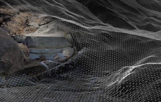
Hired by the Swiss and outfitted with Point Cloud geo-referencing technology on loan from the military (very Jason Bourne), Girot generated 3-D models of Gotthard Pass in the Alps.
Point Cloud technology relies on 7 satellites to measure several vertices on the surface of an object. The effect this extraordinary detail has when applied to the topographic extremes of the Alps was unbelievable. Even the subtle change in elevation between a cigarette butt and the pavement was mapped and charted. With all jaws agape, Girot took us on an aerial tour. We flew through mountains, hovered over the Devil's Bridge and then within a keystroke- he sectioned the landscape as if it were a nut being broken in two.
Point Cloud makes an AutoCAD rendering look like a cave drawing at Lescaeux. Current technology has only allowed landscape architects to crudely plot models of what the landscape might be. Point Cloud is so sophisticated that it actually displays what the landscape is in real-time....as you manipulate it. Genius.